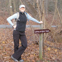
Monday, September 20, 2010

Day 160: White House Landing

Woke up to a chilly Monday morning moose hunt. Boss heard something and woke me up, and it sounded like a big old moose heading towards the water. Then it sounded like it was IN the water. It was very cold, so we weren't very quick to get out of our warm sleeping bags, but after a few minutes, we threw on our jackets, grabbed our cameras and went to find the moose!


Well, we couldn't see it from the water access, and we couldn't rock-hop around the bend in the steam, so we backtracked and followed the AT for a hundred yards or so until we heard it loud and clear. The brush was too thick to see through to the river, but it was only 20 yards away or so. It was making all sorts of weird sounds (maybe because it is rut season...?). Finally, I slowly blazed my own trail to the stream, but only saw a few ducks (and a gorgeous morning steam in the sunlight!). The moose must've crossed the stream and kept going. No moose sighting for us this morning... Just moose tracks in the mud.

We packed up and headed out on the trail to the stream that our books said we'd need to ford. I'd left my crocs on from camp. Boss took a chance and put his shoes/socks on. When we got to the crossing, it was an EASY rock-hop. Point for Boss.


The hiking in the morning was beautiful. The weather was brisk, but very pleasant. Bright sun. Flat trail. A lovely walk. We had to deal with a slight re-location of the AT going up to Little Boardman mountain. This slowed us down a bit with the new, unpredictable, unworn trail. After this mountain, however, our pace was fast, and we thought about maybe making it to the White House Landing oasis in the wilderness. It's a hostel on a lake that serves food and sells a few resupply items. It would have to be a quick, long hiking day, since we'd need to make it almost 22 miles to their boat dock before dark. I decided that we should go for it. Even if it was just for dinner...


We continued hiking at a solid pace, which was easy with the flat terrain. At least a mile of today, though, was walking on planks. They seemed to be never-ending! We stopped for lunch at a shelter where Master Chief caught up to us. We chatted a bit before taking off. We passed a logging road and watched a log truck go by (it's not too wild out here...). Later, we stopped by a bridge where we saw Prophet, his friend from home, Kim, and a ridge-runner, CJ. Prophet and Kim got a ride up to Katahdin and were hiking back to Monson. I guess I won't be seeing him again now that he's sobo. Weird.


We hiked hard and took another short break at Potaywadjo shelter to get water and check our mileage. We were going to make it! 2-something AT miles to an old road, then .2 non-AT miles east, then about a mile south to a boat dock. There's a bull horn there with a note and directions. I gave the horn a short blast, and five minutes later, Bill showed up from across the lake in his motorboat. Hi Bill!


After a quick 300-400 yard ride, we were docked out front of White House Landing. The sun was setting. The sky was dramatic. We knew we'd be staying the night. We met Linda inside as she took our orders for dinner, and we joined Backwards at a table. He was the only other thru-hiker in for the night. We each ate one of Linda's famous one-pound burgers (yum!!) and then we split a pizza. It was all delicious. Linda showed us to the bunkhouse where we dumped our packs and soon took showers. There isn't electricity in the bunkhouse (the lights all run off gas), but Linda said she would charge our phones at her house. (It was great, but it meant I couldn't blog till the next night. No worries...) Thanks Linda for sharing your power!

So, it was dark and getting cold, and there wasn't much to do without our phones. I couldn't blog, and Boss couldn't listen to his book. He ended up hopping into bed around 7:30pm, Backwards read a book by the dim light in the other room, while I took my camera down to the lake shore and took a few neat photos of the moonlight. It was SO bright! After it got too cold, I hopped into my bunk and soon fell asleep. All-you-can-eat breakfast in the morning!!!


[A few of you were concerned with my gps location! Yes, I was a bit off the trail, and this is why. I'm glad I've got you guys on my team!]
(21.8mi 6st)


-- Posted from the trail...

Location:White House Landing

Sunday, September 19, 2010

Day 159: I Saw Katahdin

Woke up in our little stealth spot and soon got to hiking. We found out how lucky we were to find that spot in the dark last night after noting that there was nothing else that would've done for camping for the next two miles. We met a few day hikers and their dogs as we all crossed the Pleasant river, which was up to our knees and cold. We also met Threshold, a 2009 thru-hiker who was working as a ridge runner.

We hiked on in the nice day. There was a bit of cloud cover, so I was worried about the view of Katahdin from White Cap Mountain later on, but it seemed like it would burn off eventually. Boss and I hiked past the loop trail to Gulf Hagas, and we were sad to do that. It's supposed to be a wonderful trail of waterfalls and canyons, but we just didn't feel the need to do the extra, 5.2 non-AT miles. We both definitely WANTED to do it, but we are just so ready to stop the walking. We pressed on instead, to get up and over the four mountains coming up...


After a short break to chat with George, a VERY talkative weekender hiker who could've gone on forever (lovely guy though), we took a lunch break at the Carl Newhall shelter (2100 mile marker!!!!) before the climb. We went up Hagas mountain, then down, then up West peak, then down, then up Hay mountain, then down, then up to White Cap where we got our first, sure view of Katahdin. And the angels sang: AHHHHH!

There she was. The light at the end of the tunnel. The goal. The legend. The reason we began. The last mountain. The northern terminus. The end.


The cloud cover had cleared, and it was a beautiful day to see that mountain from the hill on which I stood. Seventy-something odd hiking miles away. Within grasp and waiting. It was exciting, and my flame for hiking was ignited again. Only three full days to go, plus the rest of this one, and then it's Katahdin time. So hard to believe I'm already here!!

Well, we took a short break atop White Cap and enjoyed the bright sunlight. Then it was down a few miles to a shelter. Another quick break before down again to the East Branch lean-to where we will sleep. We're the only ones here, so we'll sleep in the shelter for a change. Boss and I should've picked up more fuel before heading out. He's basically empty, and I'm running low. To save what's left, Boss made a fire and boiled water over it. We both made dinner and hot chocolate without using any isobutane. I hadn't done that except for a few hot dog nights. I felt kinda like Beaver Chief.


Something to note: we didn't see ANY OTHER nobo's today! We didn't pass anyone, and no one passed us. Weird. I think we must be in between two bubbles - we'll try to catch Uncas and the Aussies, but Xan, Neutron, Deetz/PP/Miles, One Life, Rorshach, and a few others are back in Monson, about to head into the wilderness. Perhaps I'll see them all after they summit, over the weekend...?

So, with White Cap mountain out of the way now, there are no substantial mountains left before Katahdin. It should be nice, easy hiking until the last climb, so we'll be covering lots of ground. I hope this great weather continues!
(18mi 8st)

Location:East Branch Lean-to

Saturday, September 18, 2010

Day 158: Maine is Beautiful


Lovely, cold morning. After eating a hot breakfast and fixing my bear line problems, we prepared to ford the river. It wasn't too deep or far across, but it was cold, and the rocks were a bit slippery. The key is to go slow and carefully (and wear crocs). So we did (Boss wore flip flops). And we made it fine. The cold water definitely helped wake us up more!


We stopped in quickly to the shelter nearby and said good morning to Rainbow, Stryder and Farmer John. After hiking a few miles and seeing a train, we rock-hopped and took a break at a stream. Then it was up up up to the mountain-before-Barren mountain where the view was excellent. We startled some sort of moose-like animal in the woods on the way up, but I was unable to determine just exactly what it was since the woods were so thick. (It seemed like a moose though.)

We caught up with Sourdough and Sweet Dough and had lunch there with them. Master Chief stopped in, too. We were all stunned by the gorgeous view we had up there. (The lake in the photo is the geographical center of Maine!) The sun was out. Soft breeze. Lunch. Freeman swung by, heading south (he had flip flopped in Kent, Connecticut - where I saw him last). We all chatted and stared out at the mountains and lakes in the sun. It was beautiful. And it marked the "100 miles left" spot. Wow.


We left and hiked up and over Barren mountain, then down/up/down/up over four little mountains. I slipped and fell at one point, but it wasn't too bad. Just stressed out the ole left knee again. We hiked through a bog where we saw a few pitcher plants (photo - they fill up with water and somehow lower the viscosity of the water so that insects that can normally float on the service will sink to the bottom. The pitcher plants digest insects, and they look pretty cool. Thanks to Freeman for the info!) We got to the Chairback Lean-to around 5:30pm and made dinner. We wanted to shave off a few more miles from tomorrow's mileage, and stopping to eat while it was light out made it easier to night-hike, if it came to that. We said goodnight to Master Chief after getting water and pressed on.


Up on Chairback Mountain, we caught a setting sun and a lovely beginning to the evening. We walked out on the ledge and got to see the silhouettes of the mountains on the pink sky. It was quite rocky for the next mile, so there was nowhere to camp. After we slowly made it down the mountain, it got muddy... and dark. We whipped out our headlamps for the second day in a row and hiked another mile or so through a lot of scratchy brush, then mud, until we finally found a good spot.

We had already eaten, so all we needed to do was set up camp and go to bed. Nice and quick and ready to sleep. Now that we know we want to summit on the 23rd, we've worked out our daily mileages for the rest of the trip. Tomorrow will be the biggest day in the wilderness with White Cap mountain (the last real mountain before Katahdin), but pretty big miles on the remaining flat terrain till the end. I think I'm ready to be done... Only 85.8 miles left...
(19mi 8st)

Location:Tenting near the East Chairback Pond Trail

Friday, September 17, 2010

Day 157: Into the Wilderness

Woke up early and wandered out into the drizzles over to Shaw's for their famous all-you-can-eat breakfast. It was great - and it was French toast day! Boss and I sat with Master Chief, Ten Beers and Farmer John. I ordered a "three" which comes out with three of each: eggs, bacon, sausage, potatoes (servings), and pieces of French toast. I got through it and had two more pieces of French toast! Gotta fill up before the wilderness.


We chatted for a while and eventually made it back to the Lakeshore House where we finished watching a movie we didn't make it through last night. Then we packed up and got our things a bit more organized. We resupplied at the general store and had lunch at the pub (they have games to play). We chatted with Rebekah, the owner of the Lakeshore House for a while and really liked her. She runs a good show there!


After some tinkering on the computer and a few last phone calls, we packed up six days of food and made it out of town. James, the cook, gave us a ride back to the trail head after ten disappointing minutes if trying to hitch. Soon after getting dropped off, we were OFF! Into the wilderness! The HUNDRED MILES of wilderness!!! ...at 3pm...


It was a mighty late start, but we were only going 10 miles or so. My pack was heavy, but I got used to it fairly quickly. The hiking was easy and enjoyable. We passed a few ponds, rock-hopped a few streams (I sunk a foot this time... Boss stayed dry) and a sixty foot waterfall. At one of the ponds, there were two beaver swimming around, splashing. And the weather was amazing! Though we woke up to rain, it was oh-so-clear and warm while we hiked. The moon was out early, but the sun went down by 7pm and we were still moving. I forgot how short the days were getting.


We ended up pulling out the headlamps for the last 20 minutes or so and camping next to a big river crossing. We didn't want to even try to get over this river in the dark, and luckily there was a small camp ground next to it. First thing in the morning will be the deepest, strongest river ford yet. Tonight was only dinner in the dark, then bed...


One final photo: moose poo. We see it all over the place, but still no moose!
(9.7mi 6st)


-- Posted from the trail...

Location:Camping next to Big Wilson stream

Follow My GPS Locations...

I just got a faint cell signal, so I thought I'd remind you that even though I can't upload my blog entries, you can still follow my GPS location on the link on the right. I'll send out 3-5 signals a day, then on my final climb up Katahdin (on the 23rd...?), I plan to switch my SPOT to "tracking" mode, which will send out a signal every ten minutes. You can "watch" me climb Katahdin!

All for now! Things are still going well out here!


-- Posted from the trail...

Location:The 100 Miles of Wilderness

Thursday, September 16, 2010

Day 156: Reunited, and It Feels So Good!

Woke up after almost ten hours of sleep. It's nice not to have a strict schedule out here. I plan to enjoy it while it lasts... After a slow breakfast and pack-up, Boss and I left to hike the 6-ish miles to the road to Monson.


The trail was nice and rolling (a bit more uphill than I thought), but there was a really nice pond about halfway. We stopped to listen to the loons calling from far away. It was picturesque and lovely. We talked to a section hiker for a bit, then knocked out the next 3 miles. We got to the road and only waited ten minutes before Debbie picked us up on her way to Portland. She dropped us off at the Lakeshore House and waved goodbye. Thanks, Debbie!!


We self-checked in and said hello to Sour Dough (who I hadn't seen for a while), his wife Sweet Dough (who was back on the trail for the last week or so), Rainbow, Stryder and a group of three who summited yesterday - Stoker, Sour Tower and Boone. We all watched a movie and relaxed after cleaning up and throwing the laundry in. It was a relaxing afternoon. We had a bite to eat in the pub and walked over to the general store.

While we were doing all this, Scatters and Powder had finished up with Katahdin. They were DONE! Scatters' brother, Jonathan, had come out from Colorado to pick them up and drive them back to Rangeley. On their way back, though, they stopped in Monson! Happy 30th Birthday, Scatters!!! And congrats!! She managed to summit on her birthday! I knew she would :)


It was great to see Scatters again - Boss and I hasn't seen her since Hanover?! - and it was good to see Powder again, too (and nice to meet Jonathan!). The five of us went down to the pub to enjoy all-you-can-eat taco night and catch up on EVERYTHING from the last few weeks. It was excellent, and so were the tacos. Boss and I had hoped they'd spend the night with us in Monson, but they were on their way to Rangeley by 8pm. I'm so happy I get to hang out with Scatters some more, back in Rangeley after I finally summit, too. Only 114.5 miles left, and most of it will be in "the hundred miles of wilderness." It sounds daunting, but it shouldn't be too bad. We just need to bring six days of food or so. Heavy packs.

With that said, I will probably not have any cell service or internet (or battery left?) until after I summit (on the 23rd or 24th?). I will still be blogging everyday and will upload everything I've got as soon as I can. It should be a great last hundred miles, but I'm definitely looking forward to being done now.

I can't believe it's almost over...
(6.7mi 2st)


-- Posted from the trail...

Location:Lakeshore House, Monson, Maine

Wednesday, September 15, 2010

Day 155: Ford Tough

Woke up early to raindrops that came and went. Fell back asleep for a while, but was up eating breakfast by 6:45 in the shelter. Today would be an easy hike with only one mountain, first thing in the morning. Moxie Bald Mountain.


We climbed the 1000 feet of elevation in one mile and were met with fierce gusts of wind and a chilly temperature. On a clear day, you can see Katahdin, but neither Stryder, Uncas, Boss or I knew what we were looking for. It was pretty clear out, and it wasn't raining, but there are a lot of mountains up here.


On the way down, the sun really came out and warmed us up. It was especially nice since the forecast called for showers. We made it down and took a snack break at the Moxie Pond Lean-to. A really nice spot and a beautiful pond. Other hikers had noted in the register that moose come out to the pond everyday around 5pm. Unfortunately, we would miss it since it was only 10am, but perhaps another pond will have moose for us to see.


It would be nine miles until the next shelter and our next break, but when Boss and I came up to a gravel road at the halfway point between the two shelters, there was trail magic! Uncas was sitting in a chair with BJ (thru-hiker '96) and his wife Glenna. Well, hey! They had hot coffee, donuts, fruit, sodas, and lots of chocolate candy. What a treat with a warm drink! We sat down in the chairs they brought and chatted about the trail. It's really nice to hear stories from thru hiker alumni and to get advice on the last bits of trail. Thanks so much, BJ and Glenna!!


After our unexpected snack, we were powered up for the next few miles. It was really nice, mostly flat terrain, and it was right along a river. At one point, we had to ford through a swamp/bog. Boss was convinced that he could build a bridge of trees across the bog, but it was six inches deep at the shallowest point, so I just took off my shoes and socks. I slowly worked my way through the cold water to the other side, then found out there was a deeper section 15 yards away. I made it across that part (and noticed a bunch of other bare footprints), when I heard a kur-plunk and a splash, then laughter. Boss had slipped on his bridge and stepped into the bog with his shoes on. Whoops! (If he had had the time, I'm sure the bridge project would've worked out just fine...)

We hiked on and got to the Horseshoe Canyon Lean-to for one last snack. Then it was more river path walking until we crossed the east branch of the Piscataquis river on a beaver dam. There was a small campsite and a cooler full of cold drinks. More magic! We sat and had a soda, then Hat Trick showed up and did the same. He was going to push on to Monson, 6.5 miles away, but Boss and I decided to camp there and roll into town in the morning. We made a fire and ate dinner, and while we were hanging the bear bag, a beaver was splashing his tail on the river. I saw him swimming around then kur-plunk! I had never seem that happen before. Very neat and bizarre.

Lights out before 8pm again. Tomorrow = Monson. Hopefully I'll have cell service so I can upload these blogs. Last town before Katahdin, what!!?!?!


(Again on the ankle - I've never seen it look so bad! My finger is on my ankle bone in the photo, but that other bump is a hard, swollen lump of scar tissue, I think. (And yes, I will be losing my pinky toenail.) The ankle hurts a bunch, but it should last another week. Some time off in Monson should help, too. C'mon ankle!)
(15.3mi 5st)


-- Posted from the trail...

Location:Campsite on the east branch of the Piscataquis River